• The Mississippi: A Visual Biography by Quinta Scott

    "Great book and great blog - thanks for the first book I have seen that addresses the contemporary river, headwaters to gulf." Dan McGuiness, Audubon, St. Paul, Minnesota

    Click to order

  • Catagories

  • Archives

  • April 2024
    M T W T F S S
    1234567
    891011121314
    15161718192021
    22232425262728
    2930  
  • Meta

Confluence and the North American Wetlands Conservation Act


Confluence Peninsula, St. Charles County, Missouri, October 1993

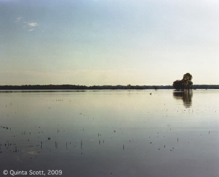
Confluence Peninsula, St. Charles County, Missouri, October 1993, during the Flood of 1993 the peninsula held 260 billion gallons of water

The Migratory Bird Conservation Commission, chaired by Interior Department Secretary Ken Salazar, approved a $999,570 grant under the U.S. Fish and Wildlife Service’s North American Wetlands Conservation Act (NAWCA) for wetland restoration in the Confluence Region of Missouri.

The Great Rivers Habitat Alliance calls this peninsula the Confluence Floodway and this region between the Missouri and Mississippi Rivers has lost 90 % of its wetlands to agriculture. Since, the Flood of 1993 developers have been looking at all that flat land and seeing subdivisions and industrial park, provided levees can be build high enough and strong enough to prevent flooding. Never mind that three times ( 1973, 1986, 1993) in the last half of the 20th century,  flooded Missouri, which runs at and higher elevation than the Mississippi, has taken a hike across the peninsula and tried to cut a new channel to the Mississippi. The alliance would like to protect up to 100,000 acres in the floodway with conservation easements. The NAWCA grant will help.


Raccoon Ranch, St. Charles County, Missouri

Raccoon Ranch, St. Charles County, Missouri


The 125 duck clubs, like Raccoon Ranch, that maintainwetlands on the peninsula, use moist soil methods to provide food for the 250  species of migrating waterfowl (4 million in all)  that visit the region every year. From October to late March, 35,000 ducks settle in for the winter.

The grant was a small part of the $26 million the NAWCA grants to protect and restore more than 200,000 acres of wetlands in the U.S. and Mexico. 

At the same time the commission approved $11.5 million to add more the 3,500 acres of wetlands to seven units of the National Wildlife Refuge System.


Riverlands, St. Charles County, Missouri

Riverlands, St. Charles County, Missouri

The Corps of Engineers maintains Riverlands in the backwaters of Lock and Dam 24 as a migratory bird sanctuary.

Riverkeepers


Confluence of the Missouri, in the foreground, and the Mississippi Rivers. The trees are on Confluence Point between the two rivers. Out from the point you can see the line of demarkation between the waters of the two rivers.

Confluence of the Missouri, in the foreground, and the Mississippi Rivers. The trees are on Confluence Point between the two rivers. Out from the point you can see the line of demarkation between the waters of the two rivers.

There was a great article about the Riverkeepers, formed by Robert F. Kennedy, Jr. and John Cronin, a commercial fisherman in the Alton Telegraph today. They were concerned about the Hudson River.

Mike Bush,  the St. Louis Confluence Riverkeeper, is concerned about the Mississippi between the Golden Eagle Ferry Crossing north of the confluence of the Mississippi and Illinois and the confluence of the Mississippi with the Meramec south of St. Louis. He also patrols  the confluence of the Mississippi and Missouri, overlooking water quality that meets 13 standards.

The Riverkeepers maintain a high visibility on the waters they patrol; look for pollution problems, the build up of silt, and the development of runnout; make sure water quality rules and regulations are followed.

Each Riverkeeper organization is dedicated to its own river and has its own web site. Go on line and learn about them. 

Confluence of the Missouri, to the right, and the Mississippi, to the left and the ripples the mixing of the waters makes.

Confluence of the Missouri, to the right, and the Mississippi, to the left and the ripples the mixing of the waters makes.

Castor River Glade


Castor River Glade

Castor River Glade

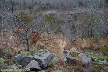
The soil on the Castor River Glade is thin and rapidly drained and the rocks exposed. It almost desert-like and it supports drought-tolerant trees, grasses, sedges, and wildflowers.

Moss and Lichen on southward facing slope

Moss and Lichen on southward facing slope

At least three different moses and one lichen carpet the pink granite bluff on which a cedar has taken root in a crevice in in the rock.

Cedars invade the glade

Cedars invade the glade

The Caster River Glade is an igneous glade that supports pineweed, prickly pear, little bluestem, pencil flower, rushfoil, wild hyacinth, flowering surge, sundrops, and fame flower. The eastern collared lizard warms itself on the exposed rocks.

The Missouri Department of Conservation has a program of prescribed burning to hold back the invasive cedars, black jack oak, post oak, and shrubs that might crowd out the grasses and wildflowers.

Igneous Forest

Igneous Forest

Moss and lichen mantled outcroppings of granite scatter through out the well-drained forest on the eastern slope of the hill bordering the Castor River Shut-ins. Slow-growing black hickory, northern red oak, and black jack oak vegetate the forest.

Hike Hickory Canyon

Hike the St. Francois Mountains, a dome ancient Precambrian rocks in the southeastern corner of Missouri. They are two and a half billion years old and were never completely buried by the inland seas. Look at a Missouri’s geological map, layer upon layer of sedimentary rocks–sandstones, limestones, and dolomites–spread out around the ancient mountains, a circular calendar of geological time: Cambrian, Ordovician, Silurian, Devonian, Mississippian, Pennsylvanian. North of the Missouri River sedimentary rocks are buried under glacial till and seldom emerge at the surface. Where they do, the results are dramatic tunnels and pinnacles. South of the Missouri River, however, the rocks lie at or just below the face of the Ozark Plateau. 

LaMotte Sandstone, Missouri’s first layer of sedimentary rocks,  eroded from the St. Francis Mountains. Missouri’s Hawn State Park and the Pickle Springs Conservation area, both in Ste. Genvieve County, are two well know places to hike the terrain created by LaMotte Sandstone.

Less well known is Hickory Canyon Natural Area, also in Ste. Genevieve County and owned by the L-A-D Foundation.  It offers two hikes, a short one, 1/4 mile, into a box canyon, and a longer one, a mile, tracks down through sandstone forests, crosses a pretty creek that flows out of a second box canyon, and returns to the trailhead. 

The 1/4 mile hike is easy down into the box canyon and easy up . It is an intimate hike that takes you along the canyon walls, where fiddle fern sprouts from a mossy substrate that is blooming.


hickorycanyonmossbloom-copy

At the foot of the trail find the intermittent waterfall, which can gush after a rain, but generally dribbles as water tumbles down from ledge to ledge.

hickorycanyonwaterfallside-copy


Winter at Hickory Canyon is an icy marvel, where melting snow slides off the bluff and freezes in a waterfall.

hickorycanyonice-copy


To get to Hickory Canyon: Exit I-55 at Missouri Highway 32 and go west to State Highway C. Turn Right. Follow C to Sprott Road, which will take you to the Hickory Canyon parking area. Signs will tell you which hike is which.